
Pictured Rocks National Lakeshore
We had a lovely day in Munising, Michigan, yesterday. Our cruise didn't leave the dock until 5:45 p.m., and so we spent the day just lazing around and sight-seeing.
Munising is another picturesque town in Michigan. If I had to choose one word to describe the Great Lakes areas that we have seen, it would be "picturesque".


Yesterday, the windows captured my photographer's eye. Someday, if I live long enough, I'd like to make a quilt of nothing but window blocks. Here are a few for my library of window images.


Mike needed a couple of items from the hardware store. After we took care of that little bit of business, we decided to take in a few of the waterfalls denoted on the town map. I've marked the ones we saw in the image below:

Horeshoe Falls turned out to be a tourist trap. We were suspicious when we saw large billboards and signs directing us to the parking lot. When we arrived, we discovered we could only enter through a gift shop. No doubt, tickets were for sale inside. We didn't even get out of the car. We saw Alger Falls along the roadside. It was less-than-impressive. On to Wagner Falls, we saw something a lot more interesting. Here's the placard at the short trail leading to the falls.


After that we drove on to Munising Falls, which is a part of the Grand Island National Recreation Area. There was a ranger on duty in the visitor center. Mike and I made the mistake of pausing long enough to use the restrooms while the ranger made her lunch break escape. Bummer. Oh well. No refrigerator magnet for me. The falls were very enjoyable. We walked another short path to reach them.


There were quite a few people there taking pictures of themselves in front of the falls. What could we do, but join in?

After that, we returned to the trailer for some relaxation and an early dinner. I had chili in my little crockpot, and it was smelling pretty good by that time. At a little after five, we headed off to board the boat for our cruise out to Pictured Rocks National Lakeshore.

It was a sunset cruise, but see that sky? No sunset for us that night, I'm afraid. Still, the cruise was very enjoyable, and I was able to get some good pictures of the Pictured Rocks.
Here's a boat like the one we were on.

The tour guide was quite a hoot, and kept us laughing with his jokes and commentary. This is the East Channel Lighthouse on the east end of Grand Island.

There is another lighthouse at the other end of Grand Island, but we didn't see it on our tour.
As I said in my post from yesterday, this is a sheltered bay. Once one heads out past Grand Island, one is on the open waters of Lake Superior where the water is much more choppy, and storms more severe. As we rounded the bend toward Pictured Rocks, this was the first formation we came to. These formations all had names, but I can't remember all of them. Our guide told us they'd toured past this formation one time to find a wedding in progress. Keep in mind that Lake Superior is in the other direction, and so this was a very scenic place to hold a wedding. Lovely.


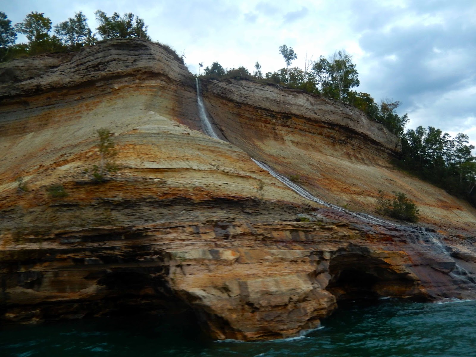
The colors you see in these images are explained by seepage of minerals into the soft sedimentary rock layers. The oranges, yellows, and lighter browns are explained by iron.


The only other way to see this area (other than by boat) is to hike the 40-mile trail that extends along the cliffs. There are steps down to sandy beaches where they exist. We did see some hikers out there too.

The water has cut caves and arches into the cliffside, and there are frequent rockfalls caused by water seeping into cracks, freezing and expanding, and then pushing the rocks away from one another. The darker color you see in the image below is caused by manganese, but also by the tannins from tannic acids in the decomposing leaves, grasses, and other vegetation growing at the top of the cliffs.

Here is one of the two arches we passed. (Arches is an incorrect use of the term, geologically speaking. "Arches" are caused by wind. "Natural bridges" are created by water. I suppose, technically, these are natural bridges, but I'm having a hard time calling this formation a "bridge". Perhaps "tunnel" is a better term. You choose.)

Our guide explained that during winter storms, waves crash into the cliffs and spray up onto the trees above. The ice can get as much as a foot thick on the vegetation. It also stunts the growth of the trees there.

Here's a formation name that I can remember: Indian Head Rock. I don't know...it looks like Richard Nixon to me.

Here's the second arch we passed. You can see that a rockfall has occurred underneath. Our guide told us that prior to the rocks collapsing here, one could drive a small boat through the opening.

The image below shows one of the most interesting things we saw on yesterday's cruise. This tree is literally hanging on by its roots. This formation is known as Chapel Rock, and a rockfall occurred between the pinnacle on which it grows and the cliff to the left, leaving its roots high and dry. My recollection of the tour commentary is that the rockfall occurred some 40 years ago, and the tree continues to survive, fed only by the roots that draw nourishment from the cliffs. Can you see how it is tethered to the cliffside in the middle left of the image below?

There were two boats on our tour. Here is the other boat, traveling behind us. It is just like the one we are on.


And that was our tour. We headed back to the dock and arrived just before dark.
As I've been writing this post a small drama has been unfolding. We were set to take off in the trailer this morning. Mike disconnected power, water, and sewer, and took down our broken jack work-around. I secured everything inside, brought in the bedroom slide, and the smaller of the living room slides. Mike brought in the catio, and as I tried to bring in the slide on the catio side of the trailer, only one side of the slide mechanism was operating, twisting the slide as it came in. I called for a consult from Mike and discovered on investigation and attempted repair that a bearing in the gearbox is frozen, making it impossible to bring in the slide.
We've both been working, consulting, and attempting to get it repaired, but to no avail. We appear to be majorly screwed. We cannot go down the road with the slide out, obviously. There are no RV repair shops in town, and the weather is getting cold, bringing a special degree of urgency to this problem. Mike is currently on the phone with a large RV repair place that we saw in Ishpeming, Michigan, some 60 miles back. We are hoping to get repairs made quickly, but we are not at all sure what is going to happen at this point. I will have to update you as everything unfolds. For now, all crossed fingers and good thoughts will be appreciated.
If we can ever get going down the road again, I did manage to re-route our trip through Iowa and Nebraska, but of course it's all up in the air right now. More later.
Pin It
More posts from Barbara Stanbro